Aug 7- 12: What happened to the last six days in Haines? You know how it goes. First you have coffee. Then you check email, etc. and have some more coffee. Maybe you make a little breakfast. Oh yeah, there’s the time it takes to discuss the blogs your hubby’s been reading since he got up four hours before you. Some days start by picking up where you left off on the book you were reading as you fell asleep last night. Of course, there’s the Jeep to get washed, the windows to clean and the floor to sweep.  And, how about the days when both of you just quickly get dressed and go out to explore the town. Occasionally you have an appointment to keep, such as the ferry across the inlet to Skagway. That’s where the six days went!
We’ve been comfortably situated at the Elks Lodge in Haines since August 6. The full hookup sites are very reasonable at $20 (lowest we’ve paid for hookups in Alaska) and the location is quiet. Even though the lodge is on “Main Street,” there just isn’t a great deal of traffic. The most activity in our area is when the lodge has their Friday Feed, hamburger night, and Tuesday Taco night. We sampled the $8.00 tacos along with four of our rv neighbors the other night. The food and the company were great. We enjoyed talking with the four solo rvers traveling together through Alaska. I should say, they are caravanning together. Two ladies have Class C’s and one lady and one gentleman each have their own motorhomes. They are from four different states and became acquainted through their singles rvers group. You can imagine the kinds of stories we all had to share.
This small Alaska town is adding a few favorite stories to our list. But if you crave the metropolitan lifestyle, Haines could disappoint you. The population, including the entire borough, is 2300 (some say that count is high). We arrived by way of the only road to town, the Haines Highway, that leads directly to the shores of North America’s deepest fjord. For those who aren’t sure, a fjord is a long narrow waterway cut through bedrock by glacier activity. 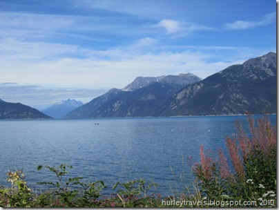 This one is called the Lynn Canal, about 2000 feet deep and 90 miles long. It channels the inside passageway from Haines to Juneau and Skagway. Haines is surrounded by glacier-topped mountains rising from the sea and rivers. You might say this is a picturesque place. Duh!! Again, as in other isolated Alaska villages or towns, it’s one of those places where you find a fair share of hardy, independent and self-sufficient individuals. People that enjoy the close-knit community where everyone knows your name, but where you might also get lost if you wish. The weather during our visit has been a mixture of cloudy and sunny, temps in the high 60s to low 70s. They say there is plenty of snowfall in the winter for all the winter sports enthusiasts. Get the picture? That’s what we like doing. We find it nice to wander around, see what’s where, listen, talk, observe and just gather the feeling of these towns and the surroundings.
So, I guess I answered my own question about where the last six or seven days have gone. Let’s see, I’ll list a few of the ways we’ve wiled the time away: 
--Drove out to Chilkoot Lake State Recreation Site to see the bears feeding on the spawning salmon. But our timing wasn’t that great. So we watched the many fishermen casting for salmon, perched on there own chosen rock or choice spot in the swiftly flowing river. A grizzly and her cubs were there just before us.
--Ate scrumptious halibut lunch, twice that is, from Big Al’s Salmon Shack, the trailer-type restaurant we found parked across the road from the wine store. 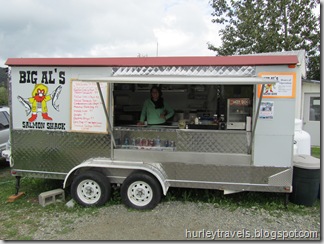 After tasting the halibut we could see why the locals were frequenting this little place. On different days out, we also discovered the excellent soups, sandwiches and coffee at the Mountain Market Cafe. Each time we drove within 1/2 mile to find perfect locations on the inlet to enjoy our lunches and the views.
--Visited the American Bald Eagle Foundation. Since Haines is known for the 4000 bald eagles that gather every fall at the Chilkat Bald Eagle Preserve, this is a logical home for the foundation. During this time of the year there are only about 400 eagles here, mostly nesting and caring for the young. Fortunately our timing was good to see the live raptor presentation and wildlife talk. We met Zilla, the Lanner Saker Falcon, who can fly up to 200 mph to catch prey, and Hunter, the Barred owl, who can rotate her head 270 degrees. And she did so to keep her eye on everybody. Since Zilla would like to have Hunter for dinner, they were carefully separated by their handlers.
We weren’t sure if we would stay for the wildlife talk. But, were pleased after a few minutes of hearing the speaker who provided some new details of various animals, for instance, the various types of salmon, their habits and traits. Of course, being in Alaska has made us more well-rounded salmon partakers. But, more questions do come up. Do we like sockeye, king, silver or what? What’s the difference between sockeye and red and chum? And why do they struggle desperately to swim upstream? Why do we see different colors and shapes of the same type of salmon? Well, we learned that the life cycle of an Alaska salmon is another wonder of nature. Among the many interesting facets is that the fish moves from river to salt water and back, readapting during the life cycle. During this readaption they change color and shape. And when these Pacific salmon adults swim upstream, they are returning to the exact place where they were born in order to spawn, just once, and then die, thereby fertilizing the stream for the new fish. After swimming over 2000 miles in the Pacific Ocean, maturing, they instinctively return to their birth streams, fighting all the way, sometimes up waterfalls. That is determination! As far as which tastes the best, we’ve done another one of those unscientific surveys and concluded it’s a personal thing. But one thing we did learn. The Chum is what they call Dog salmon and most everyone agrees that it should be kept for dog food. Now, wasn’t it important that you know this?
--Increased our reading materials at the Babbling Book. From our travels around the state and Internet reading about Haines we learned of a local author named Heather Lende. She has written a couple of books, among her many other types of writing. Her latest, “Take Good Care of the Garden and the Dogs” sounded like a good read to me. And Jerry’s interest was peaked by “If You Lived Here, I’d Know Your Name.” We stopped by the local book store and grabbed signed copies of each. If I hadn’t been writing blogs maybe I would be close to finishing my first choice, as Jerry is his. She has an engaging style.
--Rode the Haines-Skagway Fast Ferry. Without going into a long explanation of why, our general delivery mail was delivered to Skagway, a 45-minute Fast Ferry ride for humans or a one-hour Alaska Maritime Ferry ride for both the vehicles and humans. The two ferry transportation costs are logically much less for one than the other, but we were also comparing the miles to drive to Skagway, 359 miles compared to 15 across the water. After considering our options, cost of ferries, etc., we chose to make it a girl’s day, when I would have a few hours of leisurely time in the shops and museums. Skagway is the historic Klondike Gold Rush town where the multi-decked cruise ships frequent, a town that would be dubbed a tourist trap by some. One that Jerry might not find so stimulating and that I would sort through much better as a loner. So, with some concern on Jerry’s part about me going alone, I purchased the $68.00 round-trip ticket and cruised off with about 150 other passengers, mostly from the small cruise ship docked there in Haines. There was ample sunshine so the views on our short boat ride were even more outstanding.
  We had a guide/steward, presumably for the cruise ship passengers, who provided a few tidbits about the ice age and the gold rush. Did you know that John Nordstrom was a Klondike gold rusher who came in 1897 to Alaska, made $13,000 on his gold mine stake and returned to Washington to open a shoe store? You know the rest of the story.
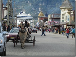
The ferry ride was smooth and quick. We were soon being dwarfed by the mammoth cruise ships on both sides of the Skagway harbor. Even though I’ve seen them before, riding alongside in the catamaran ferry conjured up images of a whale swallowing a flea. Once at the dock, it was a short walk on the 1/2 mile pathway to town and I was soon surveying my day’s activities. In a nut shell, I was  pleased to find that the historic district is a national park and surprised at the number of diamond/jewelry shops in the tiny town. I chose to go with the historic walking tour first. A small group of us followed our ranger a few blocks through town, pausing at the structures where events occurred from 1897-1900. She did a superb job of keeping us absorbed in the stories of the entrepreneurs who used their imagination and determination to build the town and become wealthy by accommodating the needs of the thousands who rushed there to find their fortunes. In essence, the business men and women in town were more successful than the miners who went into the mountains to look for their gold. I had a pleasant day of history and shopping, but passed up the diamonds and gold.
  And, of course, I picked up our mail at the Skagway post office. My ferry back to Haines was right on time. Here’s a photo as we cruised out into the Lynn Canal, away from Skagway, leaving the floating cities behind. My yellow chariot was awaiting me at the Haines dock about 40 minutes, 15 miles, southwest.
As I’m writing my post, we are still in Haines. I’m sure I’ve left out something. But this is too long already. Maybe we’ll take another drive to see if we can get a look at the bears fishing for salmon dinner or just hang out at the harbor for a while. Talk to you later.
 places we’ve been lucky enough to visit. Death Valley National Park is vibrant, colorful and diverse…even if it is the hottest place in the world. We only covered a portion of the 3,000,000 acres, but we sure did get our eyes full of spectacular scenes.
  (Oh, BTW, if you see a promo for this national park, look for us at the information kiosk at the visitors center. They filmed us as we used the self-help presentations for the park.)
 They have a high clay concentration. When you grab a piece it crumbles in your fingers. We could imagine the mule teams pulling the wagons of borax during the mining period in the late 1800s. In the Death Valley Museum in the park we saw examples of the large wagons and other equipment used in mining and processing this product in these hills.
  The name of this four-mile road tells the story. It winds through a continuous array of shades, almost as though an artist was gathering various paints for a piece of work. At one point a road sign points to the Artist Palette where you can stop to view the mounds of greens, tans and rusty-reds of this volcanic formation. As it turned out our timing was just right. We came through between 3 and 4 pm, ending our drive just as the sun dropped behind mountains to the west. The natural lighting was bringing out the best in those shades of nature. Then, as we stood watching the lights went out and all the colors were subdued.
 (That’s the first photo as I began this post.) At the top you are 5500 feet above it all, with a view of the mountains sloping up from the valley. But there is definitely a scary and chilly feature of this location. We were battling very strong winds with a 15-20 degree drop in temps as we tried to stand at the viewpoint. Here I am trying to hang on to my hat and keep my footing at my wonderful hubby tells me to stand next to the “keep back” sign. But it was exhilarating and fun up there.
  where the evaporated lake formed crusty mounds of salt down in the bottom of the valley. These crustaceans are so
 eerie and unique. We just had to touch those rough, frozen, mounds to sample the salt. Lastly, we traveled about five more miles down the road to Badwater Basin, 282 feet below sea level. There we took a walk out on the expansive salt floor. Here the erosion from the surrounding mountains has formed a 9,000 ft. basin of sand, silt, gravel and salt. This is yet another unique experience, standing on a solid, smooth, foundation of what appears to be packed salt. Occasionally a pond will survive after a rain and provide a home for small creatures that can somehow live in the saltwater. Today there was a small pond bubbling at the edge of the salt flat.


