August 2 – 6: Are you still with us on the road trip? The next segment takes us to Haines, Alaska, via the Tok Cutoff, Alaska Highway and Haines Highway. This might be the lengthiest post in miles and words in a year or so. It just belongs together. So here we go.
On the morning of August 2, after having coffee with the view of the Mount Sanford volcano, we resume our northerly trek on the Tok Cutoff. We encountered a few patches of buckling road again (photo below), but mostly we had smooth sailing with the Wrangell Mountains and Copper Valley views. 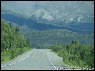 Ninety miles north we were back in the crossroads village of Tok for our second visit. We’ve written about Tok on our way into Alaska on June 2. Our one-night stopover this time was a fill-up and clean-up stop. The Chevron offers free water and dump with fill-up, plus a free overnight parking spot. They also have an rv and car wash, more seriously needed by those coming from the east on the Alaska Highway.
 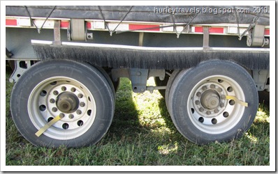 We took advantage of everything, including a nice out-of-the-way spot for the night, next to a quiet and congenial trucker. This was an opportunity for Jerry to ask a question about a peculiar feature he’s noticed in this state. See these yellow strips attached to the rims of this trailer’s tires? We’ve also seen many tires marked with yellow paint in the same manner. Why? The trucker informed Jerry that when the driver sees these markers turning he knows that his axles are not frozen. That’s how cold it gets in Alaska!
The next morning we decided to have breakfast at a popular Tok restaurant, Fast Eddy’s. The accommodating parking lot had an assortment of rvs, semis, pickups and motorcycles.  One ambitious motorcycle traveler from California had loaded his/her moose antlers onto the back. Seems to me that this biker must have wanted this rack badly.
 We had to post a couple of these shots for Tim, Bobby, Tammy, Ron, Dick and our other biking friends. Can you imagine riding from Alaska to California with this baggage? Maybe they were on the way to their new cabin in the Alaska wilderness….just up this road.
For us, it was time to travel a stretch of the Alaska Highway that we had covered in early June. At that time we were pleasantly surprised as we didn’t find the treacherous road conditions that we had heard stories about before this trip. People had warned us we might damage our vehicles on the frost heaves, have road crew delays and hit long gravel sections. This wasn’t the case when we arrived.
 But, wait. On our return two months later it’s a new story. We became acutely aware of how the thawing of the permafrost does cause havoc. The Alaska Highway trip from Tok to Destruction Bay was considerably different than when we came over a portion of this road before warm temps.
For about 175 miles, we rode the ruts, kept our eyes peeled for the orange warning flags and took it slow through the gravel areas. 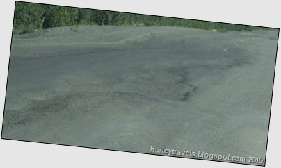 The ground
  crews were busy trying to make some sections more travelable. It’s evidently a never-ending battle. I tried to get a good shot of the heaves, but these are the best I could do, even with the new camera’s features helping to steady me. There’s one photo here of the efforts of American and Canadian scientists and engineers to slow down melting beneath the roadbed for a stable embankment. The theory is that these devices (pipes) inserted into the ground will keep it at the proper temperature so that frost heaves will not occur. Seems to be an ongoing dilemma.
The freezing of the soil also creates an issue for the black spruce trees.  Traveling through this area, probably for 150 miles, you can’t help but notice these spindly bottle brush trees covering the hills and valleys. Again, The Milepost gives me the answer. “Where black spruce thrive, few other plants can survive. They spread their roots in the boggy, shallow soil above permanently frozen ground.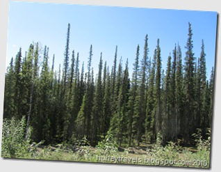
Permafrost blocks water drainage and limits root growth and soil fertility. ….a tree two inches in diameter may be 100 years old.” Also, their drooping branches invite forest fires to spread, forming a stepladder to the cones on their crown. The fire’s heat opens these resin-sealed cones, spreading the seeds for new trees to begin. Is that amazing?!
On today’s trip (August 3) on the Alaska Highway, if you are still with us after the bumps and dips, we are passing alongside and through places such as Deadman Lake, Beaver Creek, Snag Junction, Pickhandle Lake, Burwash Landing and Destruction Bay. We crossed once again through Canada Customs, into the Yukon Territory, without any concerns, passports ready. We averaged 43.9 miles per hour and traveled 237 miles in 5 hours and 23 minutes (according to Tillie the GPS). Our highest speed was 63 miles per hour, one time when we had a smooth stretch and passed someone moving at a snail’s pace. Even though bumpy, it was a good day.
In the late afternoon we stopped at what is one of my favorite spots over the past ten weeks, Congdon Creek Campground on Kluane Lake. It is a Yukon government campground, $12.00, no hookups. We were able to get a site facing the lake and shading our temperamental refrigerator. I am including a few photos that might explain somewhat my opinion of this location. The fireweed in the woods is just behind our camp site. And then, of course, there we are playing around at the lake, a short walk from Ferd.
The last part of this road trip I’ll take you on was shortened unexpectedly. On August 4 we left our Kluane Lake home, looking forward to the long stretch of lakeside driving as we continued down the road flanking this scenic waterway. But…..just a couple of miles into what would be the day’s 202-mile trip to Haines, Alaska, I smelled trouble – literally. Any kind of burning smell, of course, sends off alarms, especially when you’re riding down the road in your home. It seemed to be only in the front of the rig so we narrowed it to the small electric fan that Jerry was using for an extra breeze. Yeah, that’s it. Must be the fan motor. A quick stop at the pull off and we had replaced the fan and were smoothly rolling along again…. Not! Whiffs of that mysterious smell were back in a few minutes. And the ride seemed less smooth, too. It took us three stops, checking everyplace inside and out, in both the motorhome and the Jeep, to finally narrow down that lingering smell. Low and behold, we looked yet another time at the tires and saw up underneath the wheel well that the back, passenger side tire was definitely rubbing. Long story short…..we have a problem with our leveling system. The valve on that air bag lets out too much air (in my simplistic terms). The next town, Haines Junction, was 70 miles away. Don’t ask me to explain it technically, but with Jerry’s magic maneuvering of the leveling and the ride height on Ferd, we slowly made our way into town.
After pulling into the first empty lot we saw, we unhooked the Jeep and went into the local library to use the Internet, planning to contact fellow Foretravel owners on the internet forum. Jerry monitors the site constantly and has learned to trust the regulars for providing knowledge and advice. So, he posted a question about our problem. We hoped for some good and quick suggestions.
Meanwhile, back at the ranch…..we took Ferd slowly about two blocks further to the Kluane RV Park. Without belaboring or relating the next two days of happenings, we gathered the best advice we could and adjusted and duct taped and tested. Great news. The fix seems to be satisfactory, at least for now. But, should we make a change in our plans to go to a larger town east instead of going south? Our best evaluation is that we can proceed as is. So, we cautiously and hopefully, resumed our travels south on the Haines Highway (August 5). We haven’t noticed any more alarming smell or listing to the right side. The air bag is holding steady. Things are good until we can get back to a dependable repair facility.
 Having said all of that, we were happy we kept to our plan. The road to Haines is another byway of tremendous natural vistas. It reminded us of being in Denali National Park or the wilderness of the Denali Highway. There are no commercial entities and very little traffic for the 146 miles. Just lots of beauty.

Well, it’s been nice having you along on this portion of our journey. I’ll leave you with these last two photos from the Haines Highway, the view at our lunch spot at the summit, Chilkat Pass, and of a small creature who joined us there.
Take care. Talk to you later.


